Facts
Travel
Hotels
Restaurants
Business
Photos
|
Maps of Brasília - Television Tower
See also:
 Brasília Brasília
Brasília Maps
Television Tower
The image below shows an aerial view of the Television Tower in Brasília. For a broader view of the city, check out this map of Brasília seen from 10 miles high.
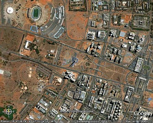 The television tower is a bit off the center, to the left, of the image below. The television tower is a bit off the center, to the left, of the image below.
The tower is located between the two expressways which make up the Monumental Axis. It is at a walking distance (about 1 km) from the hotels sectors. Click here to see photos and read more information about the Televison Tower of Brasília.
The green area is the Stadium Mané Garrincha, which will stage matches of the World Cup Brazil in 2014.
To the left of the stadium, the white area used to be Nilson Nélson Arena, which was demolished to open space for the new Stadium.
To the right of the stadium, the gray area is the Autódromo Nélson Piquet, a ring for motor races (the name was chosen as a tribute to tri-times Formula One world champion Nélson Piquet; a few years later, Piquet, who lives in Brasília, signed a contract with the government of the Federal District to manage the ring).
The distance between the tower and the stadium is about 2 kilometers.
The white building right to the south of the stadium is Centro de Convenções Ulysses Guimarães, the largest convention center of Brasília, opened in 2005. Notice that even though it is possible to walk to the convention center from the hotels sector (distance of about 4 km), the walking may be tiring.
|
|