Facts
Travel
Hotels
Restaurants
Business
Photos
|
Map of Brasília
See also:
 Brasília Brasília
Brasília Maps
Brasília Map
The images below show Brasília seen from an altitude of 10 miles. For a narrower view, check out this map of Brasília seen from 15,000 feet high.
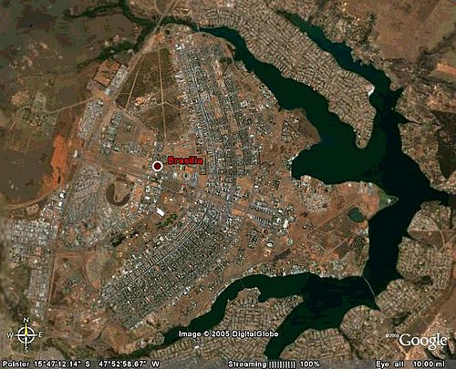 From this altitude, the airplane shape of the city becomes visible.
The wings of the airplane are Asa Norte and Asa Sul, designed to accomodate the residents of Brasilia.
The cockpit of the airplane is taken by the political center of Brazil; the Three Powers Square occupies the center of the cockpit.
From East to West, Brasilia is cut by the Eixo Monumental (Monumental Ax); the red mark is right over Palácio do Buriti, seat of the government of Brasília.
From North to South, Brasilia is cut by highways; the central highway, which separates the East from the West zones, is called Eixo Rodoviário (Highway Ax), much better known as Eixão (Big Ax).
The large green area is the Lake Paranoá.
The lake is cut by a few bridges, the newest and largest of which (bottom right of the map) is Bridge JK.
|
|