Facts
Travel
Hotels
Restaurants
Business
Photos
|
Map of Brasília - aerial view
See also:
 Brasília Brasília
Brasília Maps
Brasília - Aerial view - 15,000 feet high
The images below show Brasília seen from an altitude of 15,000 feet. For a broader view, check out this map of Brasília seen from 10 mile high.
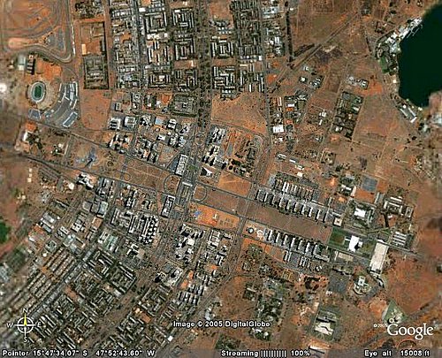 This map is focused on the central area of the Pilot Plan. This map is focused on the central area of the Pilot Plan.
The two nearly parallel lines going from right to left are the two ways of the Monumental Axis.
At the right end of the Axis, there is the Three Powers Square; the white rectangle is the yard which separates the Supreme Court from the Palácio do Planalto (seat of Federal Government).
At the left end of the Axis, this image shows the old Stadium Mané Garrincha (which was rebuilt from the ground up, in preparation for the World Cup 2014 in Brasilia); notice that the image doesn't show all the lenght of the Monumental Axis, which continues further to the left.
Between Three Powers Square and Mané Garrincha Stadium, there is a distance of about 4 km (2.5 miles).
Near the middle of the image (a bit to the left off the center), there is the crossing between the Monumental Axis and the Eixão (Big Axis); these are the two main express ways of Brasília. In this crossing zone, Lúcio Costa's Plan determined the building of the main bus station of Brasília.
The Hotel Sectors were built near the bus station. There are two hotel sectors (North and South). They are both located to the west of the Eixão; they are separated by the Monumental Axis. The North Hotel Sector (in Portuguese: Setor Hoteleiro Norte) is located north of the Monumental Ax, and the South Hotel Sector (Setor Hoteleiro Sul) is located south of the Monumental Axis.
|
|