Facts
Travel
Hotels
Restaurants
Business
Photos
|
Brasilia Maps
See also:
 Brasília Brasília
Brasília Maps
Brasília Facts
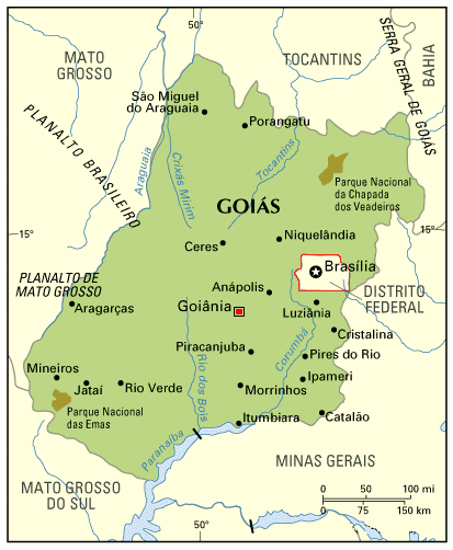
The large map shows that the Federal District is entirely surround by the State of Goiás.
For a map of the Federal Distric alone, click here.
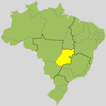
The smaller map above shows the location
of Goiás in Brazil.
Brasilia is isolated from the major Brazilian cities. The nearest capital is Goiânia, distant 200 km. Other distances: Rio de Janeiro, 1,160 km; São Paulo, 1,015 km; Belo Horizonte, 716 km; Salvador, 2,099 km.
Brasilia is point of convergence of eight federal highways: BR-010 (to Belém), BR-020 (to Fortaleza), BR-030 (to Salvador), BR-040 (to Belo Horizonte and Rio de Janeiro), BR-050 (to São Paulo), BR-060 (to Campo Grande), BR-070 (to Cuiabá) and BR-080 (to Manaus). The site of the Brazilian Department of Highways maintains a page about the conditions of the highways in the Federal District (click on the name of the highway to read reports about it).
There are bus lines connecting Brasilia to other major Brazilian cities. From Rio de Janeiro, Itapemirim takes about 17 hours and costs about R$ 150.00. From São Paulo, Real Expresso takes about 14 hours and costs about R$ 110.00.
Because of its insulation, the most practical way to reach Brasilia is flying. The airport of Brasilia is a stop for many flights connecting southern and northern Brazilian cities. By purchasing in advance, one can find prices comparable to bus fares; notice that Brasilia is quieter from Friday to Monday (when politicians return to their home towns), which reflects on prices of flights and hotels.
Brasilia has a train station, but no trains (or even railways). The RodoFerroviária is currently used by long distance buses only (whereas urban buses use the central bus station).
|
|